
March 7, 2012 Day 131
Writing: Telling
Room Submission
LA book: 1 page
Math: 2 pages
Latin: Chapter 9
prepositions
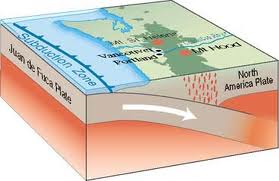
Geology 6 x 6
using Earth’s Shifting Surface
6 Vocabulary
1. Infrared: A wave of energy that is emitted by heated
objects
2. Richter Scale: A scale used measuring the intensity of an
earthquake
3. Moment Magnitude Scale: Scale that measures earthquakes
based on the size of area affected
4. Mercalli scale: scale for measuring earthquakes based on
the effects felt by humans and their surroundings
5. Shield (as in rock): Area of ancient rock at the heart of
a continent
6. Igneous rock: Rock that was once molten and has become
solid again
6 Sentences
1. By detecting the infrared satellite, which is invisible
to the human eye, we can locate undersea volcanoes.
2. There are different ways of recording the strength of
earthquakes, a common tool, is a Richter scale which is based on the
seismometer readings.
3. Scientists don’t use Richter Scales anymore because they
don’t consider it to be very accurate, especially in really big earthquakes
they prefer to use the Moment Magnitude Scale which measures the energy
released by an earthquake and the size of the area affected by it.
4. The Mercalli Scale describes earthquakes according to
their effects and damage.
5. The oldest shields of the continental crust are over 3
billion years old.
6. Rocks that form from cooling lava are igneous rock, it is
the last form of the rock cycle and an igneous rock is what we know as a rock.
6 Facts & Details
1. An Infrared can indicate if magma is rising from an
undersea volcano and give warning if an eruption is about to take place
2. In the deserts of northern Ethiopia, a new sea is forming
3. There is no water yet but the Arabian and African tectonic
plates are slowly pulling apart
4. Millions of years from now, water will rush in to the gap
5. This is the same process that formed the Atlantic Ocean
6. Scientists have been able to study it in detail thanks to
satellite observations, it is the biggest tear seen since satellite monitoring
began
6 Questions
1. How do satellites and GPS help scientist learn about
plate tectonics? A: Satellites can take pictures from a far distance of things
that are on the other side of the world and bring them back to the scientists
through computers, it can also see underground, GPS surveys the land based on
the signals it received=s from the satellites in space.
2. What are the various speeds of the Earth’s plates? A: The
northern end of the Mid-Atlantic ridge has the slowest moving plates moving
less than 1 inch in a year, The East Pacific Rise, in the South Pacific zips
along at a speedy 6 inches in one year
3. What is happening to the Earth’s crust in the desert of
North Ethiopia? A: It is tearing, creating a new sea
4. Which of the three earthquake measuring tools—Richter,
MMS, or Mercalli—do you like best? A: Mercalli; I think that the Mercalli scale
is great because it doesn’t need to use other tools of instruments like the MMS
or Richter. It is simply based on what people see and experience during an
earthquake
5. Which 3 modern volcanic eruptions have affected people in
your family? A: Mount Pinatubo, Mount St. Helens and Mount Waimaea
6. How did you do on the Quiz (page 44)? A:6 out of 7
questions right
Answer I got wrong: How many of the fastest living cities
were built in earthquake zones
My answer: 15
Right Answer: 40
6 Points of Interest from Graphic Organizer book: Physical
Weathering and Erosion—Compare and Contrast pg.12 and Concept Web
1. Water: In Chemical Weathering: combines with minerals to
form new compounds, and creates acid that breaks down rock, In Physical
weathering: Freezes
2. Air: in Chemical Weathering: Pollution in air can combine
with rain to make acids that break down rock in Physical weathering: Wind rubs
the particles it carries against rock wearing away the rock
3. Living things: Chemical Weathering: Gives out acids that
break down rock Physical weathering: Plant roots crack rock, Animals dig
through the ground and break apart rock
4. Water carries sediment downhill carving valleys between
mountains and hills
5. Ice carries rocks and sediment downhill in large frozen
masses called glaciers
6. Wind lifts smaller sediment particles and carries them to
new places through deflation
6 Images


In the Northeast part of the U.S. earthquakes are very rare and are low on the Richter Scale; some in Maine recently were at a 2.0 level. The most interesting quake event on New England was when the New Madrid quake hit near the Mississippi river; it is estimated that it was about and 8.0. It shook the ground all the way to the East coast and it caused the church bells in towers to swing enough to ring; but, there was not damage reported in New England.
ReplyDelete